Chicago-Area Trip

Planning my trip took some thinking, as I wanted to attend games at each ballpark I came across, which means there needed to be a home game. There were also a couple other events I wanted to attend that needed to line up with home games, which further complicated the matter. Finally, I wanted to spend most of the summer camping to save on money and to get that nostalgic feeling I had once experienced with my family. Therefore with tickets bought and my car packed, I set off for almost 4 months of travel. Now, this travel was broken up into smaller trips, but I spent very little time at home base in West Virginia that summer.

I made my first trip in early May with my sights set on Chicago. Just a 9 hour drive from where I was living in Huntington at the time, I had made a few trips here before and felt it was the best place to start my trip, plus it lined up with a lot of other things I wanted to do at that time. My best friend also had plans to join me once I reached Illinois, so I set off on my own.

Understanding that I would be heading back to Indianapolis on this trip, I camped south of Chicago, about halfway between Chicago and Indianapolis. I got there in one day and headed into the city on my own that first day.

Chicago White Sox

My first day in Chicago was all about the South Side, but I didn’t plan anything else, because my friend had not joined me yet. So, I made it to U.S. Cellular Field early and decided to go on a walk. That walk ended up being an approximate 6 mile round trip to Soldier Field (home of the Chicago Bears) and back, but it was a nice way to take in the sights and settle into the trip. Unfortunately, I pulled something in my leg shortly after turning back, so I had a bit of a painful trip back to baseball.

I returned to the stadium as the gates opened and headed towards the nosebleeds for my game. Now, when I picked these games, I didn’t look into more than if they were playing at home and if they fit into my schedule for the summer, so I was quite surprised to learn of the event that day: retiring Paul Konerko’s jersey. I’m not a White Sox fan, but even I knew the name Konerko, so it was an exciting thing to witness. I remember the ceremony and liking the stadium, but the game itself holds little memory for me, aside from enjoying a day at the ballpark.

Indy 500

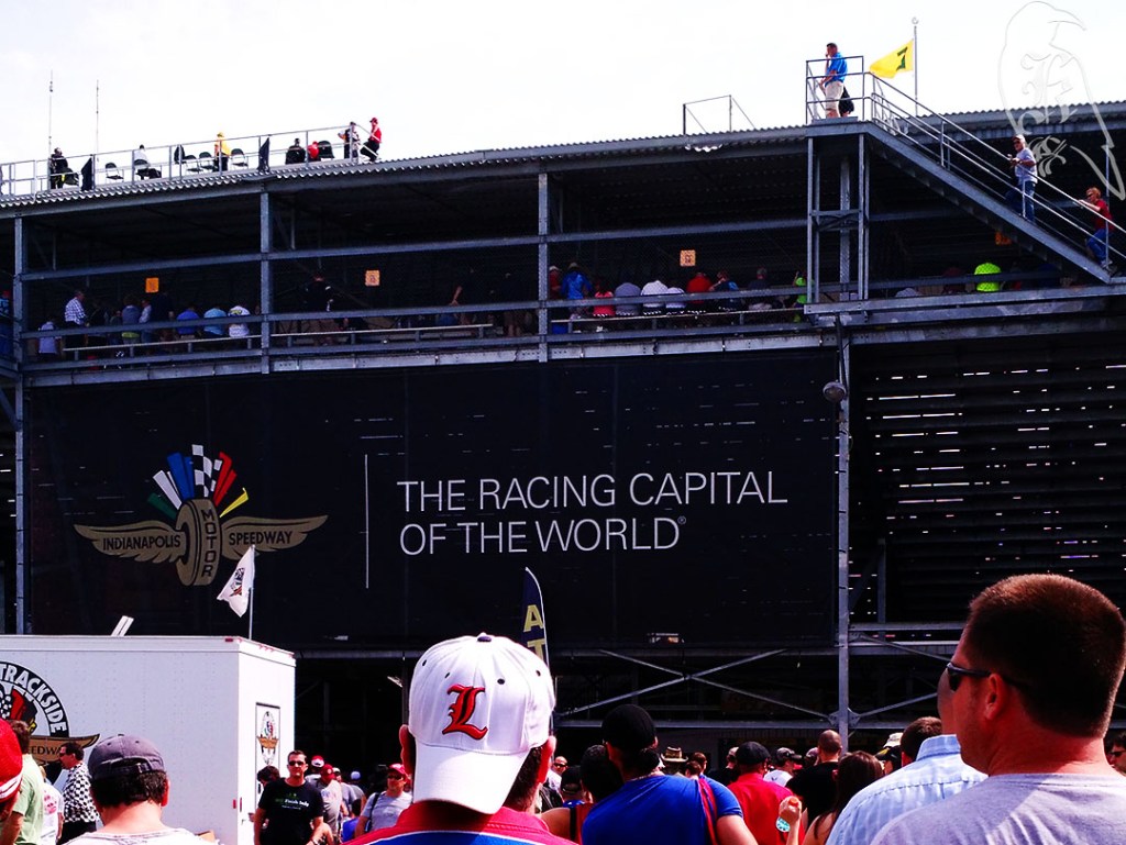
The next day led me to Indianapolis and I picked up my best friend from the train station. Fresh out of college, he joined me to cross off a bucket list item and to enjoy some baseball with me before we parted for our adult lives waiting for us (he had a fellowship and I had graduate school in a different state). 

We had acquired tickets for the Indianapolis 500 and headed off for the Speedway. While I am not a race fan at all, I would highly recommend an event like this at some point in your life. The people were great, the atmosphere was invigorating, and the only downside was the sunburn.

Wrigley Field 

We finished our portion of this trip with the Chicago Cubs (my NL team) playing the Washington Nationals (my best friend’s team). I had been to Wrigley before and this experience further solidified it as one of my favorite ballparks in the country. We explored the city a little before and after, but the day was largely about the game and the feeling of being surrounded by history.

We headed off the next morning to Minneapolis and a few stops up north before we would return to home base for a few days and head out on another trip.

Summer Trip of 2015

In the Summer of 2015, I took to the roads and visited 16 Major League Baseball parks. Originally, the idea had been to take approximately 3 months and travel the entire continental United States with my sister, but due to money and her living situation at the time, I had to make some changes. So, the summer before I started my first graduate program, I quit my job and traveled up and down the eastern United States and Canada seeing many places I had never been before.

On top of the MLB locations, I also attended the Ottawa Group Play of the 2015 Women’s World Cup and the 99th running of the Indy500. I saw several historical sites, traveled with many companions, and visited others. The Summer of 2015 still sits with some of my favorite memories and one of the times I had felt closest to my love for baseball.

Follow my journey from my memories and my photography, as I work on a larger collage project I’ve been meaning to do for years. I have broken each section of the trip down into easier ways to talk about them and will be adding the full galleries of my edited work soon!

The Picture That Started It All

I have always had a fascination with production, and spent much time as a child thinking I wanted to be a director or a photographer when I grew up. Due to lack of access to these things and developing interests elsewhere, I didn’t get much experience in either of these professions or even get to explore them in anything other than daydreams as a child.

I would grow out of my interest in directing pretty early on, though I do truly believe that it influenced my becoming a cinephile. The photography aspect would continue to fascinate yet allude me. Then, I came to the University of Michigan in 2017 and I suddenly had access to more things, including editing software that I couldn’t afford on my own.

With that, and a single picture, I rededicated my interest in photography and began to rebuild a brand I had once only thought of as a dream. It was extremely slow going, at first, with my first edit happening in the Fall of 2019 and no regular editing occurring until late 2020, but there was one picture that started it all, and began the work I enjoy today, nature photography.

Pool Pride

Pool Pride was just a camera photo I took when my brother visited me over his Spring Break one year. The photo really stood out to me though, and I wanted it to actually look the way I imagined. So, I bumbled my way through my first use of Photoshop and came out with the photo you see here. And, I got hooked.

While I still am learning immensely, I am so excited that I made this photo into something I always saw it as and that I was given the motivation to continue to teach myself. This one edit would lead to the dedication of buying a new camera for more professional photos. It would further have me learning how to edit photos and how to teach myself new tricks. Then, it would develop into a year-long goal of blogging and editing that would reintroduce the idea of a full personal and professional website for me.

What I’ve Learned and My Hiking Plans for 2022

The 52 Hikes Challenge for 2021 really grew out of a friend completing the challenge in 2020, a reintroduction to hiking for me that same year, and an attainable long-term goal I thought I could truly reach. In that way, this challenge was extremely successful, especially in a year where I made 11 trips back home to West Virginia (almost 5 full weeks of unplanned travel), often without a chance to hike, and I took a position with more responsibility that made getting away on a whim a bit more difficult.

This year was full of a lot of lows, losing 3 of my 4 grandparents, grappling with my own mental and physical health, and losing a feline companion I had had for 8 years. It was also full of highs as I gained an extremely supportive roommate (in my little brother), made some strides in my career, and did some self-work that led to being a more authentic version of myself. All of that was done while also weaving in 52 unique hikes into my year, only redoing 2 hikes I had previously completed in my entire adventure.

First and foremost, I learned that I could complete a long-term goal, which I haven’t done in awhile, especially when I have the support of friends and family. I also learned just how beautiful and diverse a place the natural aspects of Michigan are, as 49 of my hikes took place in the state. I learned the importance of proper gear and being prepared while also learning to use new things to me, like AllTrails and my new-ish vehicle.

All of these things have informed my hiking plans for 2022. I will not be completing the 52 hike challenge again, because I need a bit more freedom than that allowed and a bit less stress than can be put on you from trying to complete enough hikes, but that doesn’t mean I’m not going to challenge myself. In fact, I believe my goal this year will put me closer to being prepared for a long-distance trail in the next few years.

I started last year with the hopes of completing all 60 hikes in 50 Hikes in Michigan. Due to some previously stated issues, I have 27 left (well, 28 but there is a hike I legitimately can’t find that it suggests). My goal is to complete these remaining hikes with 10 trips throughout the year. Many of these will just be long weekends, though I do plan to do an entire week of solo hiking in mid-May to truly test what I’ve learned in the my time back in the woods.

While doing this, of course, I’ll be continuing to learn so many other things and I’ll be looking to long-distance hikers for guidance through guides, both in books and online. I also hope this helps relieve some of the stress I put on myself to produce blog posts and edited pictures in a timely fashion, as I won’t be going on as many adventures this year.

I already have my February trip planned (so stay tuned) and an idea of at least where I’m going the rest of the year, so here is to good gear, cheap hotels, and many learned lessons this year! Happy 2022!

The Final Two

My original plan, as I began to decide how to end my year, was to have one final hike on the weekend of New Years with my best friend and his husband, funnily enough, making for 50 Hikes in Michigan– although I deviated from the book itself- and 2 outside of it (West Virginia and Maryland), but that didn’t end up happening. When my final hikes got tossed up, my best friend and his partner took the reins though, and I’m forever grateful to them for that.

On December 28, I headed toward Frederick, Maryland to end the year with someone I haven’t gotten to spend nearly enough time with in recent years (I’m death glaring you COVID). He had set up a slew of activities that included a lot of the outdoors, plenty of good food, and a healthy amount of football, so I knew I was set.

My best friend from undergrad and I at Jefferson’s Rock in Harper’s Ferry. (Photo Credit: Edward Flores)

My first full day, we headed out to Gettysburg, which I’ll likely cover in a different post, and the fun just continued from there.

51 of 52

Harper’s Ferry

Day 2 included Harper’s Ferry, on both the West Virginia and Maryland sides of the Appalachian Trail and trekking through the town itself and parts of the C&O Canal Pathway. We even did some rock jumping, responsibly, in the Potomac, and the boys kept me on my toes with their extremely long legs. The trek was punctuated on both sides with some great coffee and we spent a majority of our time out and about the town talking about politics and our reasons behind why we like certain portions of American History.

While it was cool to see John Brown’s Fort and to glimpse multiple moving trains from so close, being able to chat about such things freely with such great people probably marked this as one of my favorite hikes this year. I think this particular trek really hit home that, like my best friend, his spouse is also someone I can have thoughtful conversations with, even if we don’t have similar views on things, and that none of us are afraid to state when we don’t have enough information about something to have an opinion.

52 of 52

Monocacy River Trail

The rain didn’t deter us as the boys trekked ahead of me.

Finally, on January 1, 2022, I finished my challenge. We decided it counted because Hike 1 of my 2021 challenge was on January 2, 2021 and the challenge is about personal goal reaching, not really anything beyond that. The boys were also adamant about completing it with me, because they wanted to share in the celebration of completing a long-term goal of mine. We headed out to just around their house to a trail they frequent often. Starting at a soccer pitch, we followed the Monocacy River for a couple of miles before cutting back through their neighborhood and ending up back at their brownstone, champions of a year long saga, together.

A Final Blow this Year that Almost Derailed Me

Returning home from Florida, where our family celebrated an early Christmas, I had planned on spending the weekend before Christmas knocking out a few more hikes and then enjoying some more relaxation in the last few weeks of the year. Of course, this wouldn’t happen, as we came home to find a sick cat.

I had to put my feline companion down 4 days before Christmas and caring for her meant I didn’t even touch the outdoors on a weekend I had planned for 3 treks. Then, of course, the next day, one of my fish also started showing symptoms of illness. Though, he would hold on a few more weeks.

Because of this, I almost gave up, but a short trek on Christmas with my sister, who surprised my brother and I with a visit, and a small adventure the day before I traveled for the end of the year got me back on track to complete this challenge.

49 of 52

Furstenburg Nature Area

I trek this path semi-regularly, but I hadn’t done it yet this year, so I knew it was a good option. It was only 1.5 miles and I knew the terrain would be something my sister would be able to do, as she doesn’t have much experience for the types of hikes I prefer. We headed out on a mild, rainy Christmas Day for some fresh air. Due to rain beforehand, the boardwalks were slick and there was significant mud, but we completed this adventure with very few problems.

50 of 52

Waterfall Loop

Officially, this trail was closed, but I take it the same way as I do swimming without a lifeguard, “Hike at your own risk.” I saw others on the trail, so I was confident I wasn’t the only one that felt this way. Unfortunately, the waterfall, which is why I had picked the trail, was not much of one, so some false advertising there in the name.

There was a clear erosion issue on the trail, but it did show indications of slowly being addressed in places. There was also an overgrowth issue, which made keeping the trail difficult in places. Some of these issues may have been why the trail was officially closed, but there were no further indications of why this may have been.

This path actually had to be traversed to get through the think branches.

Back to Ann Arbor

47 of 52

Scio Woods

The Sunday after Thanksgiving, I wanted to build on my momentum, recognizing the end of the year was fast approaching. I headed out to Scio Woods for a quick 2 mile jaunt before heading to my second hike of the day. I took the right entrance upon my arrival and, for the most part, followed the red arrows to stay on the path. It was well traveled and decently easy to follow. I did fall at about 0.3 miles, which made me think for a second that my day may be over, but after getting my bearings and remembering how important it is to be careful because leaves can be extremely slippery, I went on my way. The are, in general, was pretty hopping. There were only about 5 parking spots at the trailhead, but there were many more cars and you came across a decent number of people. The fact that it was a decently mild December day may have had something to do with that though.

Another photographer on the Scio Woods Trail.

48 of 52

Bluff Nature Area

For my second trek, I headed out to Bluff Nature Area for what was supposed to be a 2.8 mile hike. I ended up only going 1.5 miles because I have some issues with going in pointless circles, which much of this path was, crossing back over itself multiple times. The elevation changes also ended up being pretty rough in places, so the shorter jaunt was probably better for my legs, especially after falling earlier in the day.

A view of Downtown Ann Arbor from the Bluff Nature Area Path.

In general, I didn’t like how exposed I was, or, at least, felt. It didn’t really feel like you were in the woods, just on a stroll on the outskirts of downtown Ann Arbor. There were even some interesting views of downtown sprawled out in front of you a few times. It was cool to hike along cemetery property for a while, because I enjoy experiencing new cemeteries, but that seemed to be the only true highlight for this hike.

A Thanksgiving Adventure

Taking into consideration that much of my time away from work this year had not been for relaxation, I decided to create a unique adventure for my long Thanksgiving weekend and get back to the trails. This included 3 hikes with the possibility of over 20 miles of hiking on my own, near the Muskegon area over the holiday. Having not tested my gear since getting a new tent at the end of October, I spent the nights in a hotel centrally located near the trails and headed out for my first trek well before sunrise on Thanksgiving morning.

44 of 52

Birch Grove Connector

The Birch Grove Connector in Manistee National Forest and part of the North Country Trail has been on my list for awhile, but I had some issues in recent months dedicating that kind of time to hiking. AllTrails marked the hike at 7.5 miles, but 50 Hikes in Michigan stated 9.2. I went a little over 8 miles on the day.

The last half mile of the drive to the trailhead is unpaved, but it was well maintained, so just be prepared for that. While there are vault toilets at the trailhead, they were closed for the Winter when I was there. Also, because the trail is located in the Manistee National Forest, a Michigan Rec passport is invalid. So, if you aren’t hiking the North Country Trail and you just drive out for a day on the connector, you’ll need to come prepared with $5 for parking. There were no sign of envelopes to pay in cash, but they did have signage that got you to their portal online on your smartphone.

It was raining and about 40 degrees when I arrived, and I was on my own for the first time in a while. As I continued to hike through the day, the rain slowly turned to snow, and wouldn’t leave for the rest of the weekend. The trail consisted of Lada Lake, a Wildflower Trail (although it was dead this late in the year), and ruins, though I’m not sure of what. AllTrails was terribly marked and the lack of physical markings (aside from the blue on the trees) isn’t helpful either.

There was also significant time on the side of a road, which was quite rough on my feet after not doing such long trails for awhile.

I have decided Blue is a stupid marker color, especially if you are marking trees. On top of the lack of posts throughout the trail, when you could find a marked tree, it was hard to discern because the color bled into the bark they marked. Finally, there seemed to be some false advertising in the 50 Hikes in Michigan book, again. Like the Haven Hill Estate, there was promise of the famous NCT school house in the book, but no such luck on the trail itself.

45 of 52

Silver Lakes 

After an evening of realizing food would be hard to come by traveling on Thanksgiving, I headed out to Silver Lakes for a dune trail in the snow. Marking at the same trailhead, AllTrails marks the Silver Lakes Trail at 2.6 miles while 50 Hikes in Michigan states it to be 6 to 7 miles. The real kicker is that there is, in fact, no actual trail! This trail exists in the dunes between Silver Lake and Lake Michigan and has no true markings other than the water itself.

Have you ever seen a dead resort town? Because that is exactly what you get when you go to a lake town at the end of November in Michigan. A fresh blanket of snow had fallen overnight and the morning came with temperatures of 27 degrees with no hopes of getting much warmer. While the roads were not hard to traverse, there were definitely a few rough patches, and many of the roads in were extremely narrow.

50 Hikes in Michigan marks the trail across the dunes and then down the Lake Michigan shoreline 2.4 miles to Little Sable Point Lighthouse. I decided, keeping in mind that I had another trail tomorrow and had been out for 8 miles the day before, that I would check out the lighthouse after the hike, as I am also not a fan of walking down shorelines in my hiking boots (yes, I wear my boots even on sand dunes as they protect my ankles). This did lead me to discover that accessing the lighthouse from the beach is actually probably easier.

Still, I decided there would be plenty of workout for an out and back just to Lake Michigan, so, in full winter gear, I headed out onto the 700ft dunes. I didn’t even crest the first dune before I discovered something I’d never thought of before: frozen sand! I paused, slipped on my microspikes and kept trekking. I have decided I much prefer frozen sand to the sand I fought with earlier in the year.

As I continued my hike, I quickly discovered it is quite lonely on the dunes and I learned why walking in the desert can often be described as disorienting. It’s critical to have some form of GPS on you so you don’t get lost. There is over a mile where you are incapable of seeing anything but sand. Much of Silver Lakes is home to almost no vegetation, so I learned about Ghost Forests as I walked my lonely trek across the sand. These are dead trees and vegetation that have been claimed by the dunes.

Once I reached Lake Michigan, I had to readjust some of my gear. I did some quick repair on my microspikes and readjusted my clothes. I ended up busting my hiking pants, but with extra layers and my belt, I wasn’t left cold or exposed to the elements.

46 of 52

Dune Ridge Trail

My final day consisted of the Dune Ridge Trail before driving home, and I had a snow storm looming over the lake as I trekked. AllTrails and 50 Hikes in Michigan marked the trails similarly at 4.6 and 4.2 miles respectively. Because I tend to make things harder on myself, I ended up going 5.4 miles.

Instead of microspikes, I went with the less aggressive YakTrax on this trail. And, because I hate turning around if I don’t have to, I ended up climbing up a 1000 ft dune instead of backtracking less the a quarter mile to take the right turn. Small, achievable goals and plenty of rest was the only way I made it to the top. And, I knew, my legs were going to spend the next few days hating me. This trip led to me busting another pair of pants and relying on my handy belt again. It also reminded me why I need to double down on some of my fitness goals.

Again, the 50 Hikes in Michigan book mentioned a landmark I never saw. It stated that a blockhouse sat at the highest point in the park, but I never saw such a structure. I did come across the deserted Channel Campground, though, and I got some shots of a few deer hanging out there.

The Dune Ridge trail is actually two trails: the Ridge Trail and the Devil’s Kitchen Trail. It is largely surrounded by the waters of Lake Michigan, Lake Muskegon, and the Shipping Channel between them. Devil’s Kitchen, during warmer times, is known for the fog that rises from the swampy area (it was frozen while I was there). My suggestion would be to take the Ridge Trail first and then go through Devil’s Kitchen, as you can get the hard parts out of the way first.

Woods Creek Rustic Trail

43 of 52

Back with my brother after a couple weeks (We couldn’t hike last week because our sister was using us for some free labor), we got to have our first snow-filled trip of the season! Woods Creek was largely a ridge, which was also challenging in its own way. Add snow and the fallen fall leaves and you get a bit of a slippery mess. We were sure on our feet though, and had a fun conversation about how the experience reminded my brother of one of his favorite video games, The Witcher.

We decided along the way that we were trekking out to a “boss battle” and that was kind of fun to play around with as we enjoyed our day together. Coming home to cook some homemade chicken and dumplings and spaghetti and meatballs for the week just capped it as a good first “wintry” day in the books this year.

Shortest, Short, and Shorter

40 of 52

Miller Woods Loop

Have you ever been warned about screaming before beginning the trek around a short loop? Well, now I have, but what else did I expect with an early afternoon excursion on Halloween? A school film project brought these kids to the woods to film some horror scenes as I took my camera to enjoy the silence. Guess who got what they needed? Hint: It wasn’t me. At least, not on this trail.

This trail is extremely short at 0.3 miles but is a well marked loop in a pretty nice area. You will have to park on the side of the road, unless you are a member of the local community, but there is plenty of room for 3 to 4 cars on each side of the road.

I had originally contemplated sneakers for this trail, as it was short and I was just trying to get myself into nature, but I was glad that I always keep my boots in my trunk. The entrance to the trail was under about 3 inches of water due to its natural landscape and the constant rain from the week before. Even with my boots, the trail was slick due to the fallen leaves, but the day’s adventure truly tested the waterproofness of my hiking boots.

41 of 52

Schroeter Park Loop

After traversing the one-lane road for the last half mile to the trailhead (which might be easier to do with an AWD or 4WD vehicle), I continued to test how waterproof my boots really are. This 1.2 mile trail in Canton was the wettest I’ve come across since Bishop’s Bog, which is a literal swamp. There are about 6 parking spaces, so you don’t have to worry about that, like I have in some places.

The trail itself, while extremely wet, was a nice mix of both open air fields and actual woods, so it was a very nice way to take in those big, gulping breaths of fresh air I really needed that day.

42 of 52

Creekshead Nature Preserve Area Loop

Finally, I made it out to yet another nature preserve, but I will tell you, I almost didn’t find this one. Creekshead may be an easier trail to come across if you aren’t solo hiking, like I was that day. It was extremely difficult for me to find the trailhead, which has a sign, while I was driving up and down the road. Then, I had to park on the opposite side of the road of a pretty trafficked area, so, be careful and know your car might not be safe if you don’t get completely off the road.

It was nice that there was a pamphlet included at the trailhead that gave you some background. This type of information isn’t always still around, so I grabbed one and tucked it into my pack. The trail itself was relatively easy to traverse, although the fallen leaves, prevalent use of wood planks, and wet air and ground did make it slippery in places. The trail is tucked between two houses, but you don’t really seem to notice, so that was a nice feature as well.